Keeping an eye on the seagrass meadows
Keeping an eye
on the seagrass meadows
![]()
How do we know if the seagrass beds are recovering?
Restoring without measuring is like working blind. To determine whether our actions are working, we closely monitor the seagrass beds’ progress—on the seafloor, in laboratories, and from the sky. This is how science turns observations into answers and answers into decisions.
Three ways
to hear what the seagrasses are telling us
No single method tells the whole story. That’s why we combine complementary techniques — on the seafloor, in the lab, and from the sky. Each reveals a different perspective, and it is the combination of all of them that gives us a complete picture of the health of the seagrass meadows.
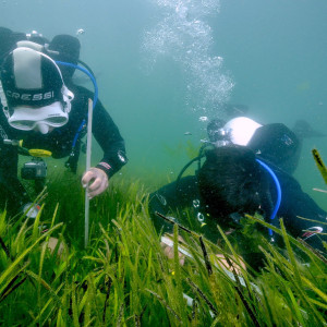
At the bottom of the sea, ruler in hand
Divers place metal grids on the seafloor — fixed structures that always demarcate the same area. Within these grids, they regularly measure the density of shoots, the height of the leaves, and the coverage of the seafloor. This is a rigorous way to determine whether the seagrass meadow is growing, stable, or in decline.
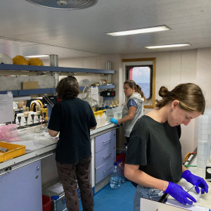
What the laboratories reveal
We collect plant and sediment samples for laboratory analysis. The sediment tells us how much carbon is stored — and for how long. The plants reveal their health and genetic diversity. This information is invisible to the naked eye, but essential for understanding the prairie in depth.
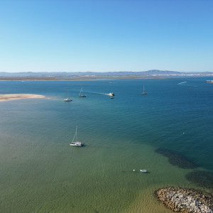
A bird’s-eye view of what lies below
Drones and satellite imagery make it possible to map large areas of the Ria Formosa and track the evolution of the salt marshes over the years. What a diver sees in square meters, technology sees in hectares — and both perspectives are indispensable.
![]()
Data That Drives Action
Every dive, every sample, every drone image feeds into a database that grows with each campaign. It is this accumulation of information over time that allows us to identify trends, adjust strategies, and, above all, determine whether the grasslands are — finally — recovering.

Keeping an eye
on the seagrass meadows
![]()
Data That Drives Action
Every dive, every sample, every drone image feeds into a database that grows with each campaign. It is this accumulation of information over time that allows us to identify trends, adjust strategies, and, above all, determine whether the grasslands are — finally — recovering.